Back Groot Soutmeer Afrikaans البحيرة المالحة الكبرى Arabic Böyük Duzlu göl Azerbaijani Вялікае Салёнае возера Byelorussian Голямо солено езеро Bulgarian ग्रेट साल्ट लेक Bihari গ্রেট সল্ট লেক Bengali/Bangla Lenn Sall Veur Breton Gran Llac Salat Catalan Velké Solné jezero Czech
| Great Salt Lake | |
|---|---|
| Ti'tsa-pa (Shoshoni) | |
 | |
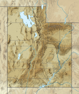
| Location | Utah, United States |
| Coordinates | 41°10′N 112°32′W / 41.167°N 112.533°W |
| Type | Endorheic lake, hypersaline lake |
| Primary inflows | Bear, Jordan, Weber Rivers |
| Catchment area | 21,500 sq mi (56,000 km2) |
| Basin countries | United States |
| Max. length | 75 mi (121 km) |
| Max. width | 28 mi (45 km) |
| Surface area | 950 sq mi (2,500 km2) as of 2021 |
| Average depth | 16 ft (4.9 m), when lake is at average level |
| Max. depth | 33 ft (10 m) average, high of 45 ft (14 m) in 1987, low of 24 ft (7.3 m) in 2021 |
| Water volume | 15,338,693.6 acre⋅ft (18.92 km3) |
| Surface elevation | historical average of 4,200 feet (1,300 m), 4,190.5 feet (1,277.3 m) as of 2022 March 14 |
| Islands | 8–15 (variable, see Islands) |
| Settlements | Salt Lake City and Ogden |
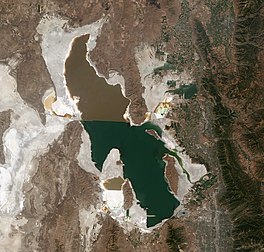
The Great Salt Lake is the largest saltwater lake in the Western Hemisphere[1] and the eighth-largest terminal lake in the world.[2] It lies in the northern part of the U.S. state of Utah and has a substantial impact upon the local climate, particularly through lake-effect snow. It is a remnant of Lake Bonneville, a prehistoric body of water that covered much of western Utah.
The area of the lake can fluctuate substantially due to its low average depth of 16 feet (4.9 m). In the 1980s, it reached a historic high of 3,300 square miles (8,500 km2), and the West Desert Pumping Project was established to mitigate flooding by pumping water from the lake into the nearby desert. In 2021, after years of sustained drought and increased water diversion upstream of the lake, it fell to its lowest recorded area at 950 square miles (2,500 km2), falling below the previous low set in 1963.[2][3] Continued shrinkage could turn the lake into a bowl of toxic dust, poisoning the air around Salt Lake City.[4]
The lake's three major tributaries, the Jordan, Weber, and Bear rivers together deposit around 1.1 million tons of minerals in the lake per year.[1] Since the lake has no outlet besides evaporation, these minerals accumulate and give the lake high salinity (far saltier than seawater) and density. This density causes swimming in the lake to feel similar to floating.
The lake has been called "America's Dead Sea"[5] and provides a habitat for millions of native birds, brine shrimp, shorebirds, and waterfowl, including the largest staging population of Wilson's phalarope in the world.[6]
- ^ a b Great Salt Lake. Encyclopædia Britannica Online. Archived from the original on February 17, 2007. Retrieved June 18, 2006.
- ^ a b "Great Salt Lake, Utah". United States Geological Survey. Archived from the original on May 6, 2009. Retrieved April 12, 2009.
- ^ "Great Salt Lake Reaches New Historic Low". USGS. U.S. Department of the Interior. Retrieved July 24, 2021.
- ^ Flavelle, Christopher; Tarnowski, Bryan (June 7, 2022). "As the Great Salt Lake Dries Up, Utah Faces An 'Environmental Nuclear Bomb'". The New York Times. ISSN 0362-4331. Retrieved August 15, 2022.
- ^ Arave, Lynn. "Great Salt Lake: A Lively Recreational Jewel". Deseret News. Archived from the original on March 21, 2006.
- ^ "Birds and Great Salt Lake". United States Geological Survey. Archived from the original on July 13, 2013. Retrieved June 19, 2006.
© MMXXIII Rich X Search. We shall prevail. All rights reserved. Rich X Search

